
Dili, February 13, 2025 (Média Democracia) – Murak Rai Timor, Public Enterprise launched activity for success held, “Drone Survey Mapping Networking” which bringing together key industry stakeholders to introduce MRT’s drone service and their application in survey mapping.
The event served as a platform for quarry operators, consultants and clients to exchange insights, explore innovative solutions, and strengthen professional networks.
According to CEO from MRT, EP José Gonçalves that in this meeting is to provided valuable insights into company’s vision and initiative.
“The event also acknowledged the Autoridade Nacional dos Minerais (ANM) for its role in supporting regulatory complience and ensuring the safe integration of drone technology into industry practices. We are committed to leveraging drone technology to enhance precision and efficiency in survey mapping.” Said José Goncalves
In this session allowed MRT, EP to engage with key partners and reinforce collaboration in adopting innovative solutions.
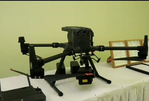
MRT President said that the engineering equipment currently owned by MRT for Drone Survey to support existing work at MRT, Ep to carry out mapping using layering techniques.
“Our existing workforce in MRT to carry out mapping with layering techniques, this technique is more advanced, so it can create mapping that can be applied to the mineral industry itself.” Said the President Director of MRT
In addition, the President continued, MRT made this mapping, it can also be used for minerals and agriculture, the principle is to make detailed mapping so that the data is good, and to make better project designs and decisions.
Meanwhile, the MRT Drone Survey Mapping Service aims to revolutionize mapping and surveying processes in the mining sector. Designed to deliver high-resolution aerial data, it enhances resource exploration and inovative decision-making processes.
“Therefore, MRT,Ep extends its appreciation to all participants and looks forward to continue collaboration in advancing drone survey technology for industry growth.” He said
On this occasion, João Soares Freitas as a Consultant for the GECOS company, appreciated the launch of MRT politics related to Advanced Drone Lidar technology to measure land, minerals, rocks, etc.
“As a consultant, I really appreciate the MRT company’s policy launched today, especially regarding the Drone Drill technology they present, previously I also heard this information, I myself brought my consultant to work with them, to collect good enough data for the mining sector.” Said João Soares
He continued, so far the GECOS company consultant has provided environmental licensing services and also mineral licensing in the rock and sand sectors.
He added that during the work there were challenges and difficulties such as drone technology facilities, therefore today’s presentation was very good.
“The previous presentation was very good for local companies and also international companies that Timor Leste also has a Drone Lidar facility that we can use to know the development of minerals in each area of the company.” Consultant João said
He informed that so far the consulting authority has encountered many obstacles in terms of equipment to be able to provide services.
“So far, the existing consultants or agencies, we also have obstacles, which is the equipment we use such as the existing GPS, Tedolin, Totestation, that’s all, so with the presence of Drone Lidar, it is to further strengthen consultant services to companies that need assistance with consultant services in the Mineral sector,” he said.
In addition, this event was attended by regional companies operating in the mineral resources sector and others.
Reported by : Estefania
Picture by : Estefania